

Tags:
At its core, Twitter is a real-time public broadcast channel. These characteristics make Twitter a natural platform for public safety communication and early-warning systems. During serious state-wide Texas rains and flooding over the 2015 Memorial Day Weekend, Twitter organically emerged as the go-to communication channel for the United States Geological Survey (USGS) and other federal, state and local agencies. As widespread power outages occurred, Twitter became an essential source for up-to-date meteorological data and agency announcements.
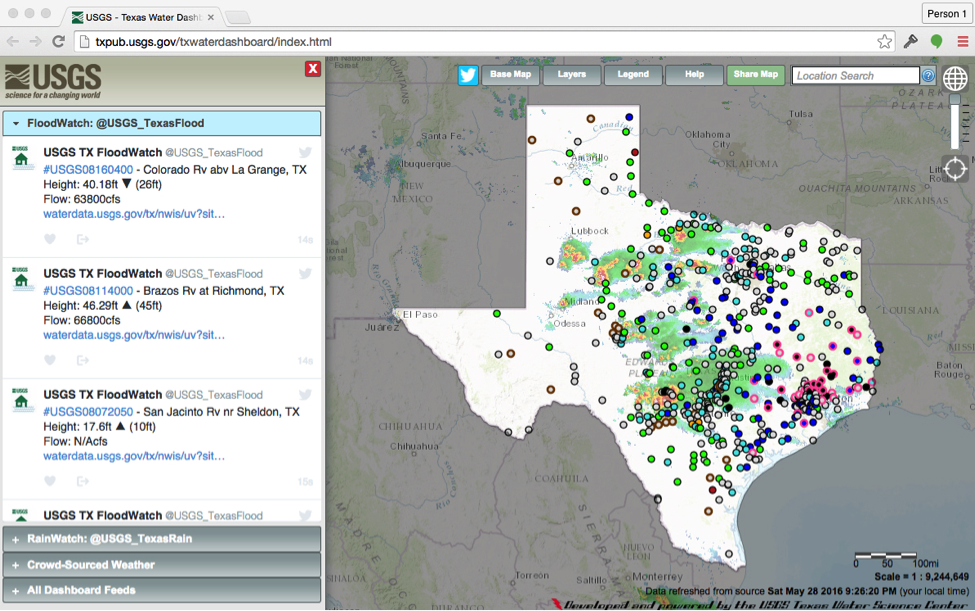
Since those events, the USGS Texas Water Science Center began exploring new ways to share real-time observation data on the Twitter platform. As a result two fully-autonomous Twitter accounts were created: @USGS_TexasFlood and @USGS_TexasRain. These Twitter accounts disseminate real-time rain and river sensor data that exceed flood-stage and rainfall thresholds. As shown in the example below, the Tweets contain unique, searchable hashtags based on the USGS site ID, current river or rain data, along with a link to that site’s page on the USGS National Water Information System (NWIS) system.
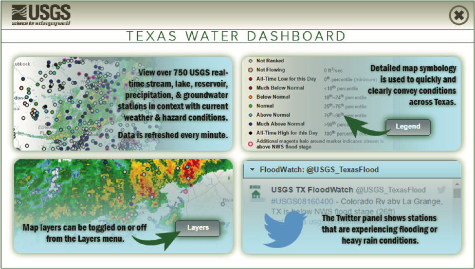
These accounts have also been integrated into the Texas Water Dashboard, which acts as the one-stop, map-based source of Texas water data. The USGS officially launched the Twitter accounts in April 2016.
To learn more about the design and evolution of these Twitter features, we contacted Daniel Pearson and Justin Robertson with the USGS Texas Water Science Center.
During Memorial Day Weekend in 2015, the State of Texas experienced major flooding events, resulting in fatalities, property damage, flash flooding, road closures and two major disaster declarations. Intense rainfall impacted nearly the entire state.
In some flood situations people lost electrical power, so their only form of communication was through their mobile devices. We realized we could leverage social media tools, like Twitter, to distribute current streamflow and precipitation data during flood events to help connect people with vital information when they needed it the most.
The USGS Texas Water Science Center wasn’t using Twitter before this endeavor. We started using Twitter to identify water-related information being Tweeted from various partner agencies and organizations during emergency management events. We realized that USGS had vital information that could be shared through Twitter to help response efforts
The USGS, on the national level, has a long and established history of using Twitter starting in 2009. The main @USGS Twitter account has more than half-a-million followers. There are more than 70 USGS Twitter-based accounts covering a variety of topics, products and services, and state-based science activities. USGS state-based accounts are focused on sharing local USGS information relevant to people living in those areas.
Twitter is a well-established social network with a large audience and has been proven to be a reliable source of information during natural disasters such as with the @USGSted (Tweet Earthquake Dispatch) effort. Leveraging Twitter as an information distribution channel allows the public to have real-time USGS data at their fingertips during times when they need it the most.
The Twitter APIs are set up to function autonomously. When streamflow at one of the selected USGS streamgages rises above the National Weather Service flood level, then a report gets Tweeted out. The same goes for when a USGS precipitation gauge reaches a certain threshold value.
Messaging was the biggest challenge for us. We spent a long time planning how to communicate the necessary information within a 140-character limit in a concise, but informative way. An initial concern was the Twitter rate limits, but by working with Twitter and explaining the public safety benefits of such a system, we were able to work through these challenges.
In the short amount of time that these accounts have been public, we’ve been surprised at the level of interest in both @USGS_TexasFlood and @USGS_TexasRain. We have followers from the general public, news organizations, professionals and scientists over a wide demographic range. The feedback received has been very positive and we’re looking forward to incorporating suggestions as these products continue to mature.
These Twitter accounts have provided a framework to potentially build upon in the future. The USGS will explore the potential value of these experimental products to the public and our partners, with potential to add other types of real-time data such as water-quality information. If successful, USGS Twitter accounts for flood and precipitation could expand to other states across the country.
Information from our Twitter feed is also being incorporated into our Texas Water Dashboard, a first-generation product from USGS that brings USGS real-time water data from over 750 observation stations together with information from NWS and other sources. This product only covers Texas at present, but has the potential to include the rest of the United States in the future.
We want to thank Daniel and Justin for speaking with us about their work, and you can read more about these efforts via a recent USA TODAY story here.
*Editor's note: As of November 2017, Twitter has increased the character count of Tweets in certain languages to make it easier to share what’s happening.
Did someone say … cookies?
X and its partners use cookies to provide you with a better, safer and
faster service and to support our business. Some cookies are necessary to use
our services, improve our services, and make sure they work properly.
Show more about your choices.